Interstate 25 southbound in Colorado Springs approaching on ramp at exit 150. Pikes Peak is in the distance. (Photo credit: Wikipedia)
JJ’s has been silent but I have plenty of adventure to share. I have been camping in the Pike National Forest, west of Colorado Springs. It’s an area with no Internet or cell. I have been blissfully out of touch since Saturday! I started out camping with my son Kerry and his girlfriend Kira and her family for two nights. I spent the third night on the south flank of Pikes Peak. I am now at a Starbucks in Woodland Park, drinking great coffee and catching up on the Internet. I have satellite radio in the van, which worked everywhere,so I am not behind on the royal baby news!
Here is my first camping trip installment: Old Stage Road
I am in the far west side of Colorado Springs, traveling through a neighborhood with older homes, security gates, and mature landscaping. The area is nestled at the base of Cheyenne Mountain. I am looking for Old Stage Road, a rugged dirt road that winds up around Cheyenne Mountain. The road sometimes follows an old stage coach trail and sometimes an old train route between Colorado Springs and Cripple Creek. I have been on this road twice before in the last ten years. Both times I remember thinking that I was glad I was not driving. The 1.5 lane road winds up and up and up, ever higher. The sheer drop is sometimes 500-1000 feet. Guard rails are noticeably absent and even a momentary glance around could lead to drastic consequences. Thankfully, a few turnouts are carved into the mountainside where I can pull over should I meet a vehicle heading the other way. Sometimes, though, you would not even know a mother vehicle was heading your way, thanks to several blind curves.

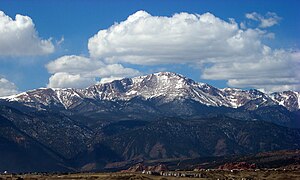
View of Pikes Peak from the University of Colorado at Colorado Springs, sometime before 2008. (Photo credit: Wikipedia)
The road is cut out of the famous Colorado red soil. As I climb, I come through ponderosa pine forests and into Douglas fir, aspen, and blue spruce trees. Ahhh, Colorado. After solid traffic on I-25 from the Wyoming/Colorado border through Denver and Colorado Springs, here I am on a winding, death defying, steep road . I vow to be brave and navigate this road without fear.
And so I travel for 17 miles. I am truly not too afraid, not like when I first moved to Colorado. Then, even the most mellow passes send me into a tizzy. For years, I begin the trip up and over a pass by turning the air conditioner and fan on high in my little car. I aim the cold blast of air at my face and make myself breathe as I climb slowly. At 8,000 feet and higher, the air is getting quite thin and I breathe deeper, trying to find that fine line between breathing and hyperventilating. Eventually, l conquer the treeless summit and pull over at the rest area. I jump out to read the signs, which usually list the elevation and any pertinent historical information about others who traversed the pass. Then—shiver—it is time to go down, which is every bit as terrifying. What if my brakes go out? What if I lose control for a minute and go over the 1000 foot drop. And on and on and on. I don’t have to travel over passes but all the places where I want to camp in those days lie over the Front Range, some over the Continental Divide

Colorado Mountain Road (Photo credit: Jaciss)
I vow that my son will not grow up afraid of mountain passes. So, part of teaching him to drive 10+ years ago included endless trips up Cheyenne Canyon, which we live near back then. We also take a trip over Monarch Pass in Central Colorado, on our way to a wilderness adventure near Lake City, CO. I already know he is a good driver and suggest that he try the pass. He did great going up but had me take over on the way down. I slid behind the wheel showing much more confidence than I really felt.

Monarch Pass sign (Photo credit: Wikipedia)
Over the years I do get braver and traverse these early passes with ease. I take on bigger challenges although I have yet to drive myself up all the way up Pikes Peak Highway or over Cottonwood Pass to Aspen. While in Glacier National Park in Montana, I plan to drive the Going-To-The- Sun Highway but chicken out. I drive the long way around to the other side of the Park.
Today it is the Old Stage Road. I am neither panicked nor totally without some fear. After 12 years driving in the Rocky Mountains I can make it up and down these roads. I am motivated. My son, his girlfriend and 4 generations of her large family are gathering for a camp out on family land in Pike National Forest. With my son and all the fun waiting up in the mountains, I will get there. There is a long way around but my son says that I should take Old Stage Road. What does he care? He has a four-wheel drive vehicle now and in recent years has driven everything from amphibious Marine vehicles in the open ocean to heavily armored tracks in Afghanistan. He is fearless. I am not. Still, I arrive to the beautiful high mountain property in one piece!

Town of Woodland Park, CO (Photo credit: Wikipedia)
Related articles
- Hairpin Turns Defined: Driving Pike’s Peak – Colorado Springs, CO (travelpod.com)
- Colorado Springs (littleknippers.wordpress.com)